
seller 3
The Lord of the Rings: The Motion Picture Trilogy (Extended & Theatrical)(4K Ultra HD)
Lord of the Rings, The: Motion Picture Trilogy (Extended & Theatrical)(4K Ultra HD)
This critically acclaimed epic trilogy follows the quest undertaken by the hobbit, Frodo Baggins, and his fellowship of companions to save Middle-earth by destroying the One Ring and defeating the evil forces of the Dark Lord Sauron.
$69.99USD

seller 3
Yankee Candle Vanilla Cupcake Scented
This Yankee Candle large jar candle is the perfect size for enjoying all your go-to fragrances. At 22 oz., the scented candle provides a long burn to add a pleasant aroma to dinner parties, lazy Saturdays, and a season's worth of little moments. Each candle from Yankee Candle is made in America with premium-grade paraffin candle wax with quality ingredients from around the world, and each wick is straightened by hand to ensure the best quality burn.
$33USD

seller 3
Ferrari F40 10248 Construction Set
Build one of the world’s greatest supercars and take it for a spin!
Includes authentic spoiler, pop-up headlights, opening rear hatch and doors, as well as detailed twin-turbocharged, 90-degree V8 engine
$550USD
seller 3
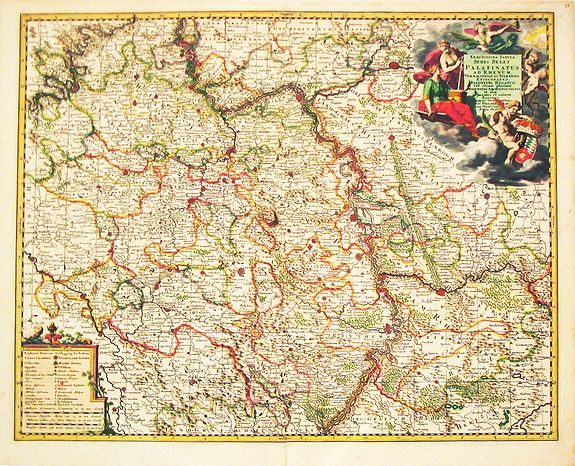
Exactissima Tabula Sedis Belli Palatinatus ad Rhenum, Vormaciensis et Spirensis Episcopatus, Bipontini Ducatus. Plus 3 other maps of the same area.
Exactissima Tabula Sedis Belli Palatinatus ad Rhenum, Vormaciensis et Spirensis Episcopatus, Bipontini Ducatus. Plus 3 other maps of the same area. Nicolaas Visscher's attractive map of Rheinland-Pfalz and south Hessen. Embellished with a very fine title-cartouche with a coat-of-arms and a cartouche with scales. From Frederick de Wit's' Atlas Maior'.
$194USD
0 bids
seller 3
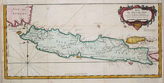
Idée de l'Isle de Java.
Jaques Nicolas Bellin (1702-720) was the most important French hydrographer of the 18th century. Sea-atlas 'Hydrographique Français' , 1756-65, atlas to accompany Prévost d' Exile's 'Histoire. des Voyages', 1738-75.A map of the island of Java.
$119USD
0 bids

seller 3
A view of Prince William Channel.Plus 4 prints of the arctic area.
A view of Prince William Channel. .Plus 4 prints of the arctic area. Captain James Cook (1728-79), explorer, circumnavigator and hydrographer. Three voyages, 1768-71, 1772-75 and 1776-79. From 1778 on printed editions of ' Captain Cook's Travels' appeared in English, Italian, French and Dutch. A view of Prince William Channel.
$194USD
0 bids
seller 3
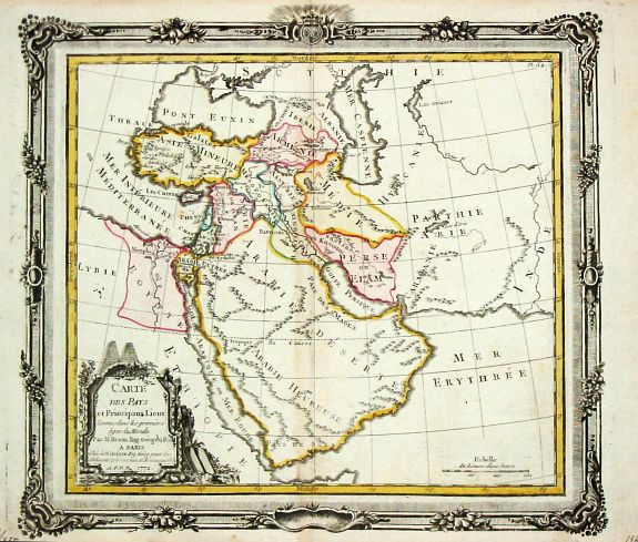
Carte des Pays et Principaux Lieux Connus dans les premiers ages du Monde.
Louis Brion de la Tour (1756-1823), ' Atlas Géneral, Civil et Ecclésiastique', 1766, ' Atlas Général', 1790-98. Louis Charles Desnos (fl.1750-70), Le Rouge's 'Atlas Nouveau Portatif', 1756, ' Atlas Général et Élémentaire', 1768-69.A map of the Near East.
$110USD
0 bids